1. Metadata
IRI |
|
Preferred Label |
ANZ National Address Model - Candidate |
Definition |
This model is a Semantic Web data model used for address information. It caters specifically for Australian & New Zealand’s address modelling needs. |
Created |
2021-12-16 |
Modified |
2022-06-11 |
Issued |
0000-00-00 |
Creator |
|
Publisher |
- |
Provenance |
This ontology was made for the Queensland Department of Resources, Spatial Information unit to assist with future Address database design. It is informed by the ICSM’s Addressing 2035: Addressing Reform and Innovation for Australia and New Zealand, published in late 2021 and is based primarilty on the ISO19160-1 Addressing Part 1: Conceptual model with additional elements from a small set of well-regarded Semantic Web models such as GeoSPARQL and SKOS. It is also informed by the relational databalse model used for the G-NAF, Australia’s Geocoded National Address File, and CSIRO work in 2018 to characterise the GNAF in Sematic Web form, the ontlogy for which is online at https://linked.data.gov.au/def/gnaf. |
Status |
Early draft |
Version |
|
Code Repository |
|
License |
|
Copyright |
© Nicholas J. Car, 2022 |
Machine-readable form (RDF) |
2. Preamble
2.1. Abstract
|
Note
|
This Model is a candidate model for Australian & New Zealand address information. It is currently an unofficial model that is not yet published as a standard. |
This model is a Semantic Web data model used for address information. It caters specifically for Australian & New Zealand’s address modelling needs. It was originally was made for the Queensland Department of Resources, Spatial Information unit, to assist with future Address database design. It is informed by the ICSM’s Addressing 2035: Addressing Reform and Innovation for Australia and New Zealand, published in late 2021 and is based primarilty on the ISO19160-1 Addressing Part 1: Conceptual model [ISO19160-1] with additional elements from a small set of well-regarded Semantic Web models such as GeoSPARQL [GEO] and SKOS [SKOS]. It is also informed by the relational databalse model used for the G-NAF, Australia’s Geocoded National Address File, and CSIRO work in 2018 to characterise the GNAF in Sematic Web form, the ontlogy for which is online at https://linked.data.gov.au/def/gnaf.
2.2. Namespaces
This model is built on a small set of well-regarded Semantic Web models which use a variatey of namespaces. Prefixes for this namespaces, used througout this document, are listed below.
| Prefix | Namespace | Description |
|---|---|---|
|
Placeholder namespace for this model |
|
|
Placeholder for the Address Roles Vocabulary |
|
|
Australian Statistical Geographies Standard Dataset, Release 3 |
|
|
Dublin Core Terms vocabulary namespace |
|
|
Generic examples namespace |
|
|
OGC GeoSPARQL |
|
|
This model’s |
|
|
|
[ISO19160-1]'s |
|
|
This model’s |
|
|
[ISO19160-1]'s |
|
This model’s |
|
|
|
[ISO19160-1]'s |
|
Web Ontology Language ontology namespace |
|
|
RDF Schema ontology namespace |
|
|
Sensor, Observation, Sample, and Actuator ontology namespace |
|
|
Simple Knowledge Organization System (SKOS) ontology namespace |
|
|
Time Ontology in OWL namespace |
|
|
Vocabulary of Interlinked Data (VoID) ontology namespace |
|
|
XML Schema Definitions ontology namespace |
2.3. Conformance
This model conforms to the OntPub Profile which is a specification for ontology publication that mandates certain structural and metadata properties for the model as a whole and model elements. Metadata elements for the model as a whole - the ontology - are given in the Metadata section above.
3. Introduction
In 2021, the Intergovernmental Committee on Surveying and Mapping established an Addressing 2035 strategy that aimed to "provide leadership, coordination and standards for assembling, delivering and maintaining address datasets". The Strategy listed "Strategic Pillars", such as "Jurisdictional flexibility" - things for Strategy implementers to aim for - "Guiding Principles", "Overarching Pain Points" and other system/model/situation requirements. It did not present an address model.
This model is created with alignment to the Addressing 2035 Strategy as a high priority, so it’s use aims to address Pain Points identified in the Strategy.
The model is mostly based on the structures of International Addressing standard, ISO19160-1, but this model is expressed in Semantic Web form. Unlike ISO19160-1, this model also re-uses elements from other, well-known, Semantic Web models, as is the Semantic Web norm.
This model does not model all of address data managers' concerns: it leaves things like the detailed modelling of spatial information to other models or extensions to this model. Also, by reusing elements from well-known Semantic Web models, this model has many "pick-up" points that can be used to join other information on to. For example, the Resource indicated as an Address Component value, may be a locally-defined simple value type - a number or string - but it may also be a complex object defined elsewhere, such as a Locality.
3.1. Address / Spatial object principle
This model details the elements of an address but not details of the spatial objects that addresses are assigned to. The general conceptual split of address/spatial object follows the Address/AddressableObject split in ISO19160-1 [ISO19160-1] with some further integration of the AddressableObject concpet with general-purpose spatial models, in particular GeoSPARQL [GEO].
The following figure overviews this model’s address / spatial object split.
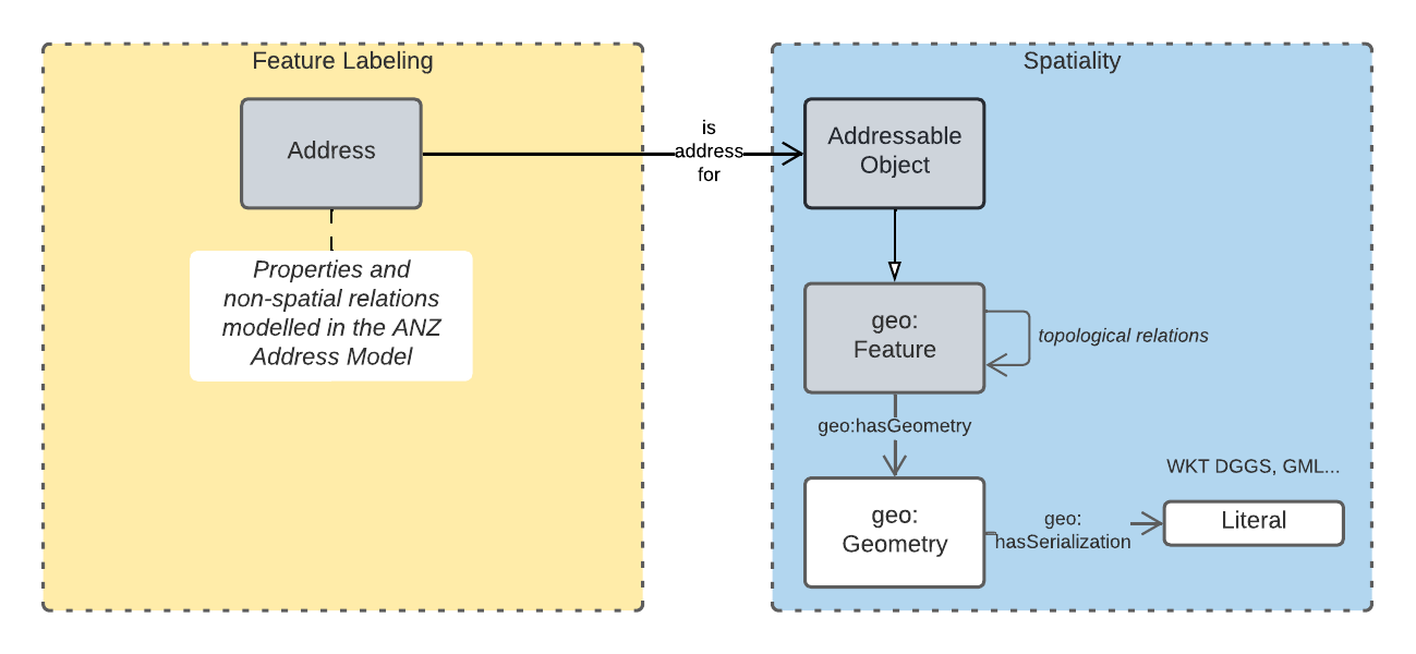
In the figure above, the spatial object that is the target of an address, an addressable object, is a subclass of (special type of) the GeoSPARQL model’s Feature class, which is really any geospatial feature. Spatial relations between addresses and other objects and spatial projects of objects (their geometries) are then modelled as spatial concerns within GeoSPARQL’s general spatial modelling.
The only exception to this are addresses' geocodes which are modeled as direct properties of (related geometries of) addresses. This is because while an address might be for a spatial object with a certain geometry, the geocode for the address might not be directly inherited from that spatial object but might be manually or otherwise defined.
For example, an emergency services access address for a hospital might need a more precise location than the footprint of the hospital property with might be large. In this case, an address with the emergency access role may be defined for the hospital with a precise point geocode which will likely be on or close to the hospital building’s boundary.
3.2. Model resources
This document is this model’s "Specification" which is its authoratitive, human-readable, definition document. This model also contains other resources with other roles:
| Resource | Role | Notes |
|---|---|---|
Schema |
The technical, machine-readable, version of this model |
|
Vocabulary |
The codelist vocabularies developed for this model and links to others defined elsewhere but used by this model |
|
Validation |
The machine-readable validator file used to validate data claiming conformance to this model |
|
Example |
Examples of data conforming, and some not conforming, to this model |
|
Example |
Demonstration implementations of this model in various database forms |
4. Model
This model is composed of Web Ontology Language (OWL) [OWL] Classes and Properties. While some of the properties are restricted in their use to various classes, the Classes and Properties are actually defined individually and both are "first class model citizens", with golbal identity, that can be used in isolation as well as together. This is in contrast to Unified Modelling Language (UML) Class Diagrams which treat Properties as sub-parts of particular classes.
This model defines some Classes and Properties and also requires certain existing Cs & Ps for reuse. All Cs & Ps in this model, both defined and reused, are listed here with an indication of where the element is difined given in the Is Defined By field.
4.1. Classes
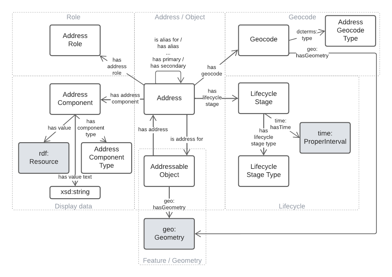
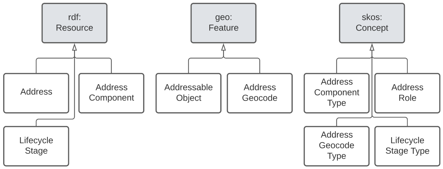
4.1.1. Address
| Property | Value |
|---|---|
IRI |
|
Preferred Label |
Address |
Definition |
The Address class represents structured information that allows unambiguous determination of an object for the purposes of identification and location |
Is Defined By |
|
Sub-class Of |
|
Provenance |
Derived from [ISO19160-1]'s |
Expected Properties |
is address for, has address component, has address role, has lifecycle stage |
Example |
|
4.1.2. Addressable Object
| Property | Value |
|---|---|
IRI |
|
Preferred Label |
Addressable Object |
Definition |
An object that is unambiguously determined by an address. Examples of types of AddressableObjects are a building, a dwelling or a land parcel |
Is Defined By |
|
Sub-class Of |
|
Provenance |
Derived from [ISO19160-1]'s |
Scope note |
Judgement as to what makes for a permissable AddressableObject rests with the implementer. This model’s technical requirements are only that the object is a legal |
Expected Properties |
|
Example |
|
4.1.3. Address Component
| Property | Value |
|---|---|
IRI |
|
Preferred Label |
Address Component |
Definition |
A component that is a constituent part of an address |
Is Defined By |
|
Sub-class Of |
|
Provenance |
Derived from [ISO19160-1]'s |
Scope note |
Address Components can be literals - numbers, words etc. - or complex ojects - Localities, districtes etc. If the Address Component is a complex object, a textual representation of it must be provided when a textual rendering of all of an Addresses' component are required, for example for letter printing. Complex objects are preferred for use over literals when the object referred to has independent identity. Ordering of Address Components, for example for letter printing, is not fixed within this model but should be implemented with a positioning preference system utilising the Address Component’s |
Expected Properties |
|
Example |
|
4.1.4. Address Component Type
| Property | Value |
|---|---|
IRI |
|
Preferred Label |
Address Component Type |
Definition |
Code that specifies the kind of address component |
Is Defined By |
|
Sub-class Of |
|
Provenance |
Derived from [ISO19160-1]'s |
Scope note |
An Address Component’s type should be indicated with values from a controlled vocabulary - a code list. A SKOS vocabulary of Address Component Types is suplied with this ontology. |
Expected Properties |
Standard properties for a SKOS Concept |
Example |
|
4.1.5. Address Lifecycle Stage
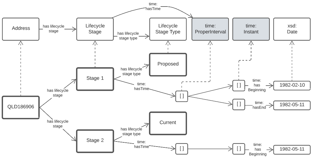
QLD186906, with Lifecycle Stages| Property | Value |
|---|---|
IRI |
|
Preferred Label |
Address Lifecycle Stage |
Definition |
Represents the different lifecycle stages of an Address |
Is Defined By |
|
Provenance |
Derived from [ISO19160-1]'s |
Scope note |
An Address Lifecycle Stage’s type should be indicated with values from a controlled vocabulary - a code list. A SKOS vocabulary of Address Lifecycle Stages is suplied with this ontology. In this model, these Lifecycle Stages are defined for use with Addresses only, not also Address Components, as per ISO19160-1. |
Expected Properties |
Standard properties for a SKOS Concept |
Example |
|
4.1.6. Address Lifecycle Stage Type
| Property | Value |
|---|---|
IRI |
|
Preferred Label |
Address Lifecycle Stage Type |
Definition |
Code that specifies the kind of Address Lifecycle Stage |
Is Defined By |
|
Sub-class Of |
|
Provenance |
Derived from [ISO19160-1]'s |
Scope note |
An Address Address Lifecycle Stage’s type should be indicated with values from a controlled vocabulary - a code list. A SKOS vocabulary of Address Lifecycle Stage Types is suplied with this ontology. |
Expected Properties |
Standard properties for a SKOS Concept |
Example |
|
4.1.7. Address Role
| Property | Value |
|---|---|
IRI |
|
Preferred Label |
Address Role |
Definition |
AddressRole represents a task for which this Address may be used |
Is Defined By |
|
Sub-class Of |
|
Provenance |
Derived from [ISO19160-1]'s |
Scope note |
ISO19160-1 does not contain an |
Expected Properties |
Standard properties for a SKOS Concept |
Example |
|
4.1.8. Geocode
| Property | Value |
|---|---|
IRI |
|
Preferred Label |
Geocode |
Definition |
A Feature used to position other Features and to carry typing or provenance of that position |
Is Defined By |
|
Sub-class Of |
|
Provenance |
Derived from the G-NAF’s expression of Address position |
Scope note |
Indicating a Geocode for an Address with the property hasGeocode is a direct method of locating the Address. Addresses either may or must also be located by ference to an Addressable Object which has a Geometry, depending on business rules. |
Expected Properties |
|
Example |
|
4.1.9. Geocode Type
| Property | Value |
|---|---|
IRI |
|
Preferred Label |
Geocode Type |
Definition |
The type of Geocode, typically determined by creation method |
Is Defined By |
|
Sub-class Of |
|
Provenance |
Derived from the G-NAF’s Geocode Type codelist |
Expected Properties |
Standard properties for a SKOS Concept |
Example |
|
4.2. Properties
4.2.1. is address for
| Property | Value |
|---|---|
IRI |
|
Preferred Label |
is address for |
Definition |
Indicates an Addressable Object that an Address is allocated to |
Is Defined By |
|
Sub-property Of |
|
Inverse Of |
|
Provenance |
Derived from [ISO19160-1]'s object relations |
Domain |
|
Range |
|
Example |
|
4.2.2. has address
| Property | Value |
|---|---|
IRI |
|
Preferred Label |
has address |
Definition |
Indicates an Address has been allocated for an Addressable Object |
Is Defined By |
|
Inverse Of |
|
Provenance |
Derived from [ISO19160-1]'s object relations |
Domain |
|
Range |
|
Example |
|
4.2.3. has address component
| Property | Value |
|---|---|
IRI |
|
Preferred Label |
has address component |
Definition |
Indicates an Address Component of an Address |
Is Defined By |
|
Provenance |
Derived from [ISO19160-1]'s object relations |
Domain |
|
Range |
|
Example |
|
4.2.4. has address component type
| Property | Value |
|---|---|
IRI |
|
Preferred Label |
has address component type |
Definition |
Indicates an Addresses Component’s type |
Is Defined By |
|
Provenance |
Derived from [ISO19160-1]'s object relations |
Domain |
|
Range |
|
Example |
|
4.2.5. has address role
| Property | Value |
|---|---|
IRI |
|
Preferred Label |
has address component type |
Definition |
Indicates an Address Role for an Address |
Is Defined By |
|
Provenance |
Derived from [ISO19160-1]'s AddressPosition class and properties |
Domain |
|
Range |
|
Example |
|
4.2.6. has geocode
| Property | Value |
|---|---|
IRI |
|
Preferred Label |
has geocode |
Definition |
Indicates a refined, that is a very accurate or specific, geometry, usually a point, for an Address qualified by the Geocode Type - how it was generated. |
Is Defined By |
|
Provenance |
Derived from the G-NAF’s expression of Address position |
Scope Note |
This property, along with hasRole, allows multiple Addresses with different locations to be allocated to Addressable Objects and for those addresses to be used for different purposes. The location indicated by this property should be within/on/next to the location of the Addressable Object this Address is for, within some acceptable tolerance. |
Domain |
|
Range |
|
Example |
|
4.2.7. has lifecycle stage
| Property | Value |
|---|---|
IRI |
|
Preferred Label |
has lifecycle stage |
Definition |
Indicates an Addresses' Lifecycle Stage |
Is Defined By |
|
Provenance |
Derived from [ISO19160-1]'s object relations |
Domain |
|
Range |
|
Example |
|
4.2.8. has value
| Property | Value |
|---|---|
IRI |
|
Preferred Label |
has value |
Definition |
Indicates the value of an Address Component |
Is Defined By |
|
Provenance |
Derived from [ISO19160-1]'s AddressComponent object’s properties |
Domain |
|
Range |
|
Example |
|
4.2.9. has value text
| Property | Value |
|---|---|
IRI |
|
Preferred Label |
has value |
Definition |
Indicates the textual rendering of an Address Component |
Scope note |
This property is to be used to represent the textual value of Address Components that are literals and also complex objects. For a literal, the same value will be present for hasValue and hasValueText, e.g. a street number of 20 or a property name of "Bonnie Doon", however for a complex object, e.g. the locality |
Is Defined By |
|
Provenance |
Derived from [ISO19160-1]'s AddressComponent object’s properties |
Domain |
|
Range |
|
Example |
|
5. Supporting Vocabularies
This model uses many vocabularies to give specific values to classification properties for Address, AddressComponent and to qualify relationships within the model. This section lists those vocabularies and summarises their content but not their full content which is instead linked to.
Four vocabularies expected for use with this model are defined here, within the model. Others are defined elsewhere, mainly ICSM vocabularies derived from AS4189 or the G-NAF.
Those defined here are:
Three of these vocabularies are derived from vocabularies (codelists) within [ISO19160-1] but all are extended for use here. The remaining vocabulary - Address Role Types - is derived from the various elements of [ISO19160-1] but not directly from one vocabulary.
Those defined as ICSM vocabularies:
-
Address Types
-
Address Alias Types
-
Address Role Types
-
Flat Types
-
Geocode Types
-
Level Types
-
Street Suffix Types
-
Street Types
|
Note
|
Hyperlinks to these vocabularies will be provided as soon as persistent identifiers for them are issued. Until then, the content of these vocabularies can be found within the submission to register them: https://github.com/GeoscienceAustralia/icsm-vocabs/pull/13/files. |
5.1. Address Component Types
This vocabulary is an extended version of [ISO19160-1]'s AddressComponentType vocabulary. The original 8 concepts from the standard are included however only one of them - postcode - is suggested for use within this model. An additional 19 concepts are taken from address elements in the G-NAF, such as numberFirstSuffix. A further 4 concepts have also been added during the design of this model to cater for newly understood future ANZ addressing needs, such as placeName and indigenousPlaceName.
| IRI | Status | Usage directive |
|---|---|---|
|
original |
Do not use: handled by |
|
original |
Do not use: use object reference types |
|
original |
Do not use |
|
original |
Use |
|
original |
No not use: use |
|
original |
Do not use |
|
original |
Use |
|
original |
Do not use, use |
|
addition (G-NAF) |
Use |
|
addition (G-NAF) |
Use |
|
addition (G-NAF) |
Use |
|
addition (G-NAF) |
Use |
|
addition (G-NAF) |
Use |
|
addition (G-NAF) |
Use |
|
addition (G-NAF) |
Use |
|
addition (G-NAF) |
Use |
|
addition (G-NAF) |
Use |
|
addition (G-NAF) |
Use |
|
addition (G-NAF) |
Use |
|
addition (G-NAF) |
Use |
|
addition (G-NAF) |
Use |
|
addition (G-NAF) |
Use |
|
addition (G-NAF) |
Use |
|
addition (G-NAF) |
Use |
|
addition (G-NAF) |
Use |
|
addition (G-NAF) |
Use |
|
addition (G-NAF) |
Use |
|
addition (G-NAF) |
Use |
|
addition |
Use |
|
addition (this model) |
Use |
|
addition (this model) |
Use |
|
addition (this model) |
Use |
5.2. Address Lifecycle Stage Types
This vocabulary is currently as per [ISO19160-1]'s AddressLifecycleStage vocabulary, however it is expected that this vocabulary will be extended early in its use in Australia/NZ as it is know that jurisdictions within ANZ use other statuses
| IRI | Status | Usage directive |
|---|---|---|
|
original |
Use unless superseded |
|
original |
Use unless superseded |
|
original |
Use unless superseded |
|
original |
Use unless superseded |
|
original |
Use unless superseded |
|
original |
Use unless superseded |
5.3. Address Role Types
This vocabulary is inspired by [ISO19160-1]'s AddressPosition and AddressPositionType classes and the often repeated need in ANZ to assign purposes to Addresses. All elements are original in this model.
| IRI | Status | Definition |
|---|---|---|
Usage directive |
|
deliveries |
An address to use for deliveries |
Use |
|
emergency access |
An address to use for emergency services' access |
Use |
|
service connection point |
An address at which utility services are connected |
Use |
|
site office |
5.4. Address Status Types
This vocabulary is an extended version of [ISO19160-1]'s AddressStatus vocabulary.
| IRI | Status | Usage directive |
|---|---|---|
|
original |
Use unless superseded |
|
original |
Use unless superseded |
|
original |
Use unless superseded |
Annex A: Validators
A.1 Description
Two validators to test data claiming conformance to this model are provided as resources within this profile. The first, validator.ttl is the canonical validator for this model. The second, validator-qld.ttl is a demonstration validator for Queensland that includes extended validator rules building on validator.ttl.
A summary of the canonical validator’s elements ("shapes") is given in Table 1.
| Shape ID | Description |
|---|---|
|
Checks the mandatory properties of |
|
Checks the mandatory properties of |
|
Checks the mandatory properties of |
|
Checks the mandatory properties of |
|
Note
|
The canonical validator’s list of elements will almost certainly grow as use of this model fleshes out model element needs. |
A.2 Use
These validators are implemented using the Shapes Constraint Language (SHACL) and any tool that support SHACL validation may be used to apply them to data to be validated.
Some examples of such tools are:
-
-
free and open source Python SHACL validator
-
-
-
online Javascript-based validator
-
-
-
online pySHACL-based validator
-
Any of those tools may be used to apply the Canonical or Queensland validator to data and produce a report of the validity of the data.
Annex B: Extended Examples
The extended examples for this model are a series of data files stored in this model’s online code repository:
Each file there exemplifies a modelling situation or problem and the modelling within the data gives this model’s solution. The particular situation/problem is explained at the start of each file. For example, in the file locan-01.ttl, we have:
# Logan 1
# Multiple Parcels - 1 Address
#
# Address: 714 Stockleigh Road Stockleigh QLD. Parcels: 378RP849082, 477W31578
# &
# Address: 38 & 40 Augustus Street Kingston. Parcels: 57RP38148 and 57RP38148
where Logan 1 is the example name, Multiple Parcels - 1 Address is the scenario descriptor and the remainder the details of the examples in text.
As per the inline examples in this document, all example data is RDF data represented using the Turtle syntax, as per Conformance.
Annex C: Demo Implementations
Several demonstration implementations of this Address model are given in the code repository containing its content.
C.1 RDF Database Demo
The 15 or so extended examples data files within the code repository (see above Annex for details) represent an implementation of this model for they are formulated in RDF data and are thus able to be loaded into an RDF database (often called a "triplestore") and queried.
To demonstrate this, the multiple example files can be loaded directly into such tools as Apache’s Fuseki database. They can also be combined into one file using RDF tooling and that uploaded. The script _compound_example.py in the examples directory compounds all the examples into the single file _all.ttl.
Once loaded into a triplestore, SPARQL queries can be used to interrogate the data similarly to how SQL queries are used for relational databases. Some example SPARQL queries for the examples data are:
C.1.1 Ordered Address Components
For those Addresses that have components - not all in the example data - this query orders the components as per Queensland norms, including the new Property Name type component at the start.
PREFIX addr: <https://w3id.org/profile/anz-address/>
PREFIX dcterms: <http://purl.org/dc/terms/>
PREFIX actiso: <http://def.isotc211.org/iso19160/-1/2015/Address/code/AddressComponentType/>

SELECT ?a ?ac_type ?val ?val_text
WHERE {
    VALUES (?ac_type ?ac_order) {
        (actiso:buildingName 1)
        (actiso:propertyName 2)
        (actiso:indigenousPlaceName 3)
        (actiso:flatTypeCode 4)
        (actiso:flatNumber 5)
        (actiso:numberFirst 6)
        (actiso:streetLocality 7)
        (actiso:locality 8)
        (actiso:postcode 9)
        (actiso:administrativeArea 10)
    }
    ?a a addr:Address ;
        addr:hasAddressComponent [
            dcterms:type ?ac_type ;
            addr:hasValue ?val ;
            addr:hasValueText ?val_text
        ]
}
ORDER BY ?a ?ac_order
This query selects only Address Components of the types given in the VALUES list and orders them as per the integer numbering given. Results for the example address 2/18 Oxford Place (see extended-examples/oxford-place.ttl) are:
| ?a | ?ac_type | ?val | ?val_text |
|---|---|---|---|
|
|
"2"^^xsd:integer |
"2" |
|
|
"18"^^xsd:integer |
"18" |
|
|
|
"Oxford Place" |
|
|
|
"Shorncliffe" |
C.1.2 Selecting addresses by geocode type and in an area
The following query selects addresses from the examples that have a Geocode of type Property Access Point (PAP) and that are within the Bounding Box of 154 -27, 154 -28, 153 -28, 153 -27, 154 -27.
PREFIX addr: <https://w3id.org/profile/anz-address/>
PREFIX dcterms: <http://purl.org/dc/terms/>
PREFIX geo: <http://www.opengis.net/ont/geosparql#>
PREFIX geof: <http://www.opengis.net/def/function/geosparql/>
PREFIX gct: <https://linked.data.gov.au/dataset/gnaf/code/geocodeType/>

SELECT ?a ?wkt
WHERE {
    ?a a addr:Address ;
        addr:hasGeocode [
            dcterms:type gct:PAP ;
            geo:asWKT ?wkt ;
        ] .

    FILTER (geof:sfWithin(?wkt, "POLYGON ((154 -27, 154 -28, 153 -28, 153 -27, 154 -27))"))
}
The results from this query are:
| ?a | ?wkt |
|---|---|
|
"POINT(153.157220 -27.624450)" |
|
"POINT(153.157220 -27.624450)" |
|
"POINT(153.045546 -27.341745)" |
Two of the results have the same geocode location. This is due to a:GAQLD155231408 being a primary address with a:GAQLD161337673 being a secondary and sharing a Property Access Point location (geocode).
Without the spatial bounding box filter, we would also get one more result:
| ?a | ?wkt |
|---|---|
|
"POINT(151.95179638 -28.82625239)" |
Removing the geocode type filter, we get all of the Addresses that have Geocodes, and the Geocodes' values, in the extended examples: there are 19.
So SPARQL queries can filter results on type and also using spatial relations, such as within a given area.
C.1.3 Selecting Addresses in relation to an object
SPARQL queries can select Addresses based on Address Component values which may either be literal values (numbers/strings) or complex objects.
To get all the example Addresses within the Queensland locality of Shorncliffe:
PREFIX addr: <https://w3id.org/profile/anz-address/>
PREFIX loc: <https://linked.data.gov.au/dataset/gnaf/locality/>

SELECT ?a ?val ?val_text
WHERE {
  ?a addr:hasAddressComponent/addr:hasValue loc:loc38f189794e03
}
This query finds two results (the oxford-place examples) since they indicate they have Shorncliffe as an Address Component of type actiso:locality by reference to the GNAF Locality PID https://linked.data.gov.au/dataset/gnaf/locality/loc38f189794e03.
To find all of the Addresses in Queensland we could use the PID of Queensland given by the Australian Statistical Geography Standard since that’s the object ID related to in this examples data
PREFIX addr: <https://w3id.org/profile/anz-address/>
PREFIX loc: <https://linked.data.gov.au/dataset/gnaf/locality/>

SELECT ?a ?val ?val_text
WHERE {
  ?a addr:hasAddressComponent/addr:hasValue <https://linked.data.gov.au/dataset/asgsed3/STE/3>
}
Note that the PID for Queensland is external to this model but resolves, online to the ASGS Queensland object:
C.2 Relational Database Demo
The 15 or so extended examples within the code repository (see above Annex for details) have been stored in an SQLite Database also within this code repository.
|
Note
|
To be fully functional, the SpatiaLite extension to SQLite need to be enabled so spatial functions may be performed. This extension is NOT enabled for this demonstration database to keep the geometry data human-readable (text) rather than implementing it as binary data types. |
The database consists of 21 tables that together store:
-
the primary data of the examples
-
the Addresses in table addresses, Address Components in address_components etc.
-
-
the codelists/vocabularies listed in Supporting Vocabularies
-
as lookups
-
-
an IRI prefixes table
-
mapping short form IRIs to complete IRIs
-
as per Namespaces
-
These tables fully represent the content of the examples and the database schema used is therefore a complete relational implementation of this model.
To show equivalence to the RDF Database Demo, the three SPARQL queries shown there are reimplemented as SQLite SQL queries next.
Additionally, C.2.4 Converting relational to RDF data demonstrates how to convert some of the content from this relational implementation to RDF so it may be validated using the validators in Annex A: Validators.
C.2.1 Ordered Address Components
The following query yields identical results to that in C.1.1 Ordered Address Components:
SELECT *
FROM addresses_components
ORDER BY
  address_pid,
  CASE type
    WHEN 'actiso:buildingName' THEN 0
    WHEN 'actiso:propertyName' THEN 1
    WHEN 'actiso:indigenousPlaceName' THEN 2
    WHEN 'actiso:flatTypeCode' THEN 3
    WHEN 'actiso:flatNumber' THEN 4
    WHEN 'actiso:numberFirst' THEN 5
    WHEN 'actiso:streetLocality' THEN 6
    WHEN 'actiso:locality' THEN 7
    WHEN 'actiso:postcode' THEN 8
    WHEN 'actiso:administrativeArea' THEN 9
  END
C.2.2 Selecting addresses by geocode type and in an area
To make an SQL query equivalence to the sPARQL query in C.1.2 Selecting addresses by geocode type and in an area, an SQL join between the addresses and geocodes tables must be performed:
SELECT pid, geometry
FROM addresses
JOIN geocodes
ON addresses.pid = geocodes.address_pid
WHERE type = 'gt:PAP'
AND MBRWithin(
        GeomFromText('POLYGON ((154 -27, 154 -28, 153 -28, 153 -27, 154 -27))'),
        geometry
    );
Results from this query are the same as those in C.1.2 Selecting addresses by geocode type and in an area.
|
Note
|
For true operations, the function MBRWithin requires a GEOMETRY data field to operate on, not text as this example geometry field is. This example uses text so the values can be read. Removing the MBRWithin clause from the query above results in 4 results from the SQLite database, as per the reduces SPARQL query example above.
|
C.2.3 Selecting Addresses in relation to an object
The following SQL query performs equivalently to the first query in C.1.3 Selecting Addresses in relation to an object.
SELECT address_pid, has_value, has_value_text
FROM addresses_components
WHERE has_value = 'loc:loc38f189794e03'
Results for this query are the same as the equivalent SPARQL query.
|
Note
|
To match on a full IRI for 'loc:loc38f189794e03', which the equivalent SPARQL query above does with use of the prefix statement PREFIX loc: https://linked.data.gov.au/dataset/gnaf/locality/, the SQLite table pid_prefixes can be consulted to interpret 'loc:' in the query below.
|
C.2.4 Converting relational to RDF data
Since content according to this model can only be canonically represented in RDF, it is necessary that all other forms of content claiming conformance to this model show they can be converted to RDF for canonical data validation using the validators in Annex A: Validators.
The following SQL query obtains all the information necessary to formulate RDF for the valid example address http://example.com/oxford in the file extended-examples/oxford-place.ttl:
SELECT
    a.pid, a.is_address_for,
    ac.type, ac.has_value, ac.has_value_text,
    g.geometry, g.type,
    aa.address_pid
FROM addresses a
JOIN addresses_components ac
ON a.pid = ac.address_pid
JOIN geocodes g
ON a.pid = g.address_pid
JOIN address_aliases aa
ON a.pid = aa.alias_pid
WHERE a.pid = 'ex:oxford';
In the query above, a 4-table join is performed to obtain Address, Address Component, Address Geocode and Address Alias data.
A simple string templating function in a programming language such as Python may be used to convert those results into RDF or an RDF toolkit, such as Python’s RDFLib or Java’s Jena, may be used.
The file rdf_converter.py is a Python script that:
-
reads the Relational Database Demo file
-
utilises the pid_prefixes to map prefixed data to full IRIs
-
extracts all the elements of the
http://example.com/oxfordusing the query above -
adds all elements ton an RDF graph
-
prints the graph to text
The resultant graph is valid according to both of the validators files in Annex A: Validators, just as the original in the extended-examples folder is.
C.3: G-NAF for Queensland Demo
The entire contents of the Geocoded National Address File (G-NAF) for Queensland have been converted into this model’s relational form as per the SQLite implementation described above in C.2 Relational Database Demo.
This complete conversion demonstrates this model’s ability to represent the entire content of the G-NAF for Queensland but it is too large to include in this model’s code repository. It may be obtained on request from this model’s author.
Bibliography
-
[GEO] Open Geospatial Consortium, OGC GeoSPARQL - A Geographic Query Language for RDF Data, Version 1.1 (2021). OGC Implementation Specification. http://www.opengis.net/doc/IS/geosparql/1.1
-
International Organization for Standardization, ISO 19156: Geographic information — Observations and measurements (2011)
-
[ISO19160-1] International Organization for Standardization, ISO 19160-1: Addressing Part 1: Conceptual model (2015). https://www.iso.org/standard/61710.html
-
World Wide Web Consortium, OWL 2 Web Ontology Language Document Overview (Second Edition), W3C Recommendation (11 December 2012). https://www.w3.org/TR/owl2-overview/
-
World Wide Web Consortium, The Profiles Vocabulary, W3C Working Group Note (18 December 2019). https://www.w3.org/TR/dx-prof/
-
World Wide Web Consortium, The Profiles Vocabulary, W3C Working Group Note (18 December 2019). https://www.w3.org/TR/dx-prof/
-
W3C Schema.org Community Group, schema.org. Community ontology (2015). https://schema.org
-
World Wide Web Consortium, Semantic Sensor Network Ontology, W3C Recommendation (19 October 2017). https://www.w3.org/TR/vocab-ssn/
-
[SKOS] World Wide Web Consortium, SKOS Simple Knowledge Organization System Reference, W3C Recommendation (18 August 2009). https://www.w3.org/TR/skos-reference/
-
World Wide Web Consortium, RDF 1.1 Turtle Terse RDF Triple Language, W3C Recommendation (25 February 2014). https://www.w3.org/TR/turtle/